skip to main |
skip to sidebar


On a fine, bright winters day I set out to visit a series of megalithic monuments and stone circles in the east of Cumbria, a county which holds a third of all the stone circles in England. The concentration of prehistoric monuments in the county is testament to the importance of the area to our ancient ancestors but the questions I wished to explore by visiting these sites was what made this area so attractive, why were these sites chosen as special and then marked in such a visible way by the erection of massive stone monuments.
The night before my journey I had sat down with my 1:25000 OS maps spread over the floor and carefully planned my route so that I could cover as much ground as quickly as possible and it was with a light heart and a blithe spirit that I set out with my itinerary tightly scheduled. In the tangle of small lanes and minor roads that criss-cross the countryside south of Appleby my tightly scheduled itinerary began to unravel when I found the road I wished to take was being dug up by a team of navvies and was firmly closed. A quick glance at the map showed that I could get in from the west rather than the east but this would necessitate a lengthy detour however all was not lost as my new route would take me through the village of Orton and close to the circle at Gamelands. So I threw the itinerary out the window and trusted to my sense of direction.
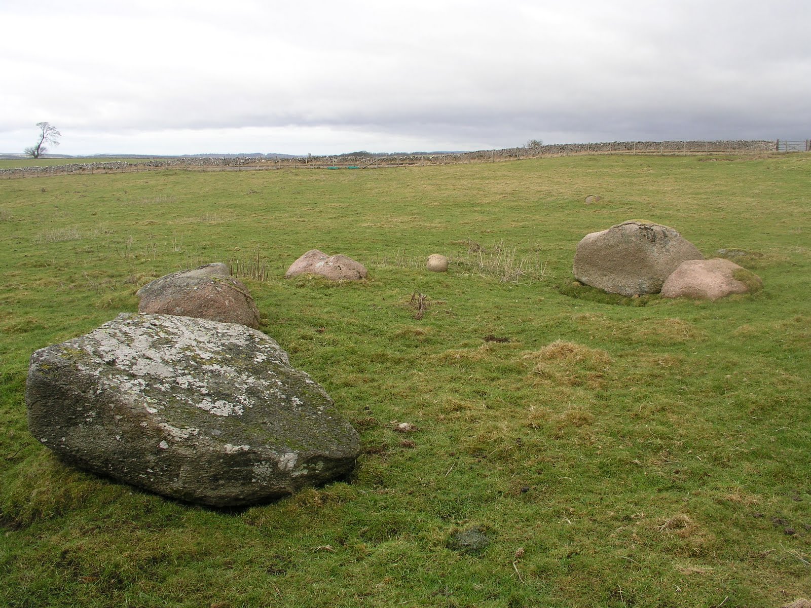
Orton is a small and visibly affluent village sitting in a green low-lying hollow between the massive limestone scar to the north east, the Howgill hills to the south and Lakeland fells to the west. The village has all the necessary features of the chocolate box lid – white-washed stone cottages, a church with a high tower and large country houses with their own drives scattered around the perimeter. Leaving the village along the B6261 and driving east along the foot of the scar you come to Knott Lane, a small and rocky track leading to the stone circle. It was bitterly cold with the winds seeming to blow from every direction at once as I set off up the lane on foot. The map showed the circle to be on the eastern side of the dry stone wall, which at this point was around 5 feet high. I peered over the wall from the advantage point of a large mossy stone and there it was – 33 large pink granite boulders (actually 32, one of the boulders is limestone and badly weathered and pitted) in a rough broken circle with sheep tracks between. A quick look over my shoulder to make sure I was alone then an even quicker climb over the dry stone wall, here made with large stone slabs that acted as steps, and I was down the other side and among the circle.
Gamelands is a large structure, around 40 metres in diameter, with some very large stones, which although fallen still retain their sense of scale and presence. The stones themselves are glacial erratics of Shap granite, deposited in this predominantly limestone area by the retreating ice of the last glaciation. They have an easy and worn shape, like a boiled sweet that has been sucked smooth. The pink feldspar crystals, or phenocrysts, give the stones a fleshy, organic look – almost like the backs of subterranean animals breaching the surface of the earth. In the bitter winds I walked around the circle and touched the stones, noting the blue pieces of piping discarded in the middle – the ubiquitous agricultural litter of the British countryside. Nobody was around. Very few cars passed by on the road to the south. Only the sheep watched me and then only briefly, returning after quick glances to the grass that was much more important.


What was special about this place? Why here? These are the critical questions with stone circles – purpose and location, location and purpose. For all the theories about stone circles as cattle pens, astronomical instruments, tribal centres and meeting places I feel that the answer is much more simple and often very obvious, if only one looks up from the theodolite, slide rule and tape measure. Such huge, megalithic structures require planning and resources – not just brute labour but intellectual resources and spiritual resources. The circle is here because ancient people wanted to mark this place – and if we look around we quickly see that the most dominant topographical feature is the massive bulk of Knot Hill looming over the stone circle from the north. The presence of this hill must be significant to the location of Gamelands stone circle – perhaps because of it’s shape, rounded and prominent, or the fact that it’s limestone geology and hydrology marked it as different and worthy of celebration.
We have lost the stories and lore that explained the significance of the location but it can be partially regained; with a sensitivity to place and lines of sight, with an understanding of the direction of valleys and passes, with an awareness of how the ebb and flow of the landscape impacts on the lives of plants, animals and people we can begin to rebuild the lost lore of Ancient British Animism that lies buried with the megaliths and rock-art of these islands.


My route now took me through the moorland north west of Orton and on towards Shap. The small town of Shap sits on the far eastern fringe of Lakeland like a poor relation at a wedding celebration. Despite the efforts of the council and tourist board to market Shap as “Gateway To The Eastern Lakes” it remains a working class town with a very visible industrial presence along the length of its linear plan. It feels like a place where you are more likely to see hi-vis vests and rigger boots than designer mountain jackets, which is a good thing. Of course in the stone age Shap and the hill sides around the present town were at the centre of a large and complex ritual landscape marked by a network of stone circles, megalithic avenues, cairns and standing stones. Driving over the moors from Orton every other rock catches ones attention and it is possible to see broken cairns and opened cists at every bend in the road. I would love to spend more time here and test to see if my suspicions are bourn out but the day is already moving on and I have too many things to do.
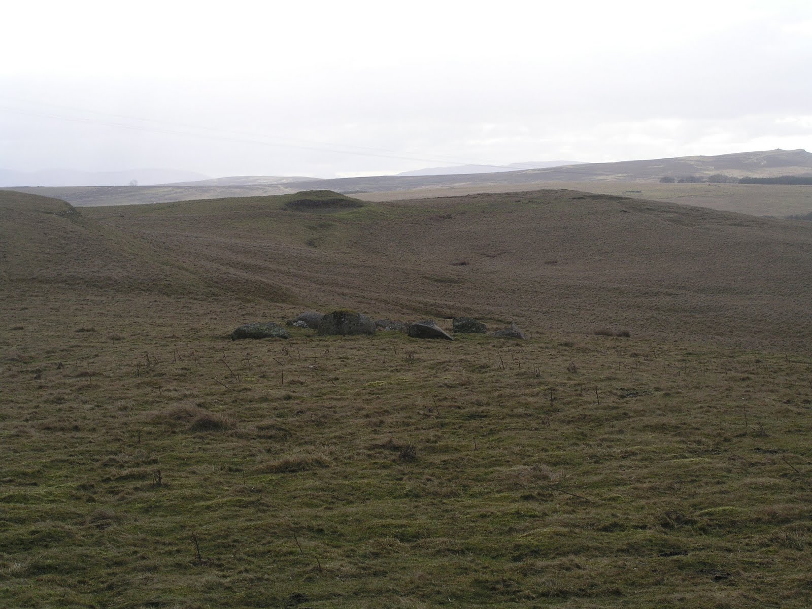
Castlehow Scar is a small and ruinous stone circle that is, quite frankly, hardly worth the effort of visiting were it not that it is on the way to other, more impressive sites. One crosses the M6 heading east out of Shap, rising up to the long ridge that runs north-south from Penrith to Tebay. At the crest of the ridge and in the lee of a long narrow plantation of spindly, under-nourished sitka spruce the stone circle stands up against a wire fence and a dry stone wall. Public access is not allowed and I had to balletically climb and balance across the barbed wire fence but it really wasn’t worth the trouble. After the vast scale of Gamelands this is an anti-climax. The sense of bewilderment and let-down is increased by the obstruction caused by the plantation, which cuts off all views to the fells at the far east of the vale of Eden. But ones eye is drawn westwards to nearby Shap with it’s complex of megalithic monuments and the siting of Castlehow Scar stone circle must be part of this wider landscape, with its views to the amphitheatre of High Places that surround the Vale of Eden. Even so, Castlehow Scar circle is not something that I would travel to see again.


Carry on down the lane from Castlehow Scar, round the southern end of the ugly 1959 spruce plantation and onwards towards the isolated farmstead of Oddendale and you can visit the twin sites of Iron Hills North and South, otherwise known as Haberwain. There is a long straight green-lane leading up from the corner of the road, up towards the ridge line that attracted the eye of these ancient architects. There are so many erratics in the fields around Haberwain, and often in vaguely regular distributions that one can get confused and “stone crazy” but it is worth remembering that in this part of the world stone circles occur, like fox shit, in prominent places with clear lines of sight and that means the summit of the ridge
.
There is some debate as to whether Iron Hills North is actually a stone circle or the remains of a ruined cairn with its base stones exposed. That there is a large cairn-shaped mound in the middle, with a dry stone wall cutting through it, would suggest the latter. Never the less this is an impressive site and one that affords clear lines of sight to other High Places around the panorama – including the large glacial trough of High Cup Nick, the edge-like summit of Wild Boar Fell, the massive of the Howgill Fells to the south and the wall of Grey Crag and Bannisdale Fell behind Shap.
Who was buried in a place like this? John Salkeld Bland’s 1910 book “The Vale Of The Lyvenett” has an anecdotal and frustratingly romantic account of the “careless” opening of the cairn “a few years ago”, which revealed a human skeleton allegedly of “gigantic proportions” (what else), fragments of red deer antler and a “bronze dagger” described as thirteen inches in length. We may snigger at the exaggeration of the size of the skeleton and Bland’s fanciful assertion that the man “opposed the advance of the Roman legions” – he may have been as removed from Roman Britain as us – but this is a place of obvious and significant importance.
At How Tallon above Barningham Moor – 40 miles to the east – there is a Bronze Age burial cairn that affords similar lines of sight to high hills along the valleys of the Swale, Greta, Tees, Wear and even (on a clear day) the Tyne. There is also a small stone circle at the head of a prominent gill, a place that provides a permanent spring and which is commemorated by spectacular rock art panels. Here at Haberwain is a similar site – a burial mound with panoramic views, sited within a large and complex ritual megalithic landscape. The effort of erecting these burial mounds in such places, with thin soil and steep ascents, must have been considerable. Are we confident that our family and friends would go to such lengths for us when we die? Will our graves occupy a place where the High Places can be seen? Will there be anything of importance for our souls to see?


Some modern commentators have expressed their dislike, even their disgust for the large open cast limestone quarry to the west of this site, claiming it to be a scar on the landscape and not in keeping with the ancient monuments that surround it. I feel that this attitude does not sit well with the tradition these sites represent. The North Pennines and Cumbrian fells have always been places of industry and extraction – coal, lead, iron stone, slate, granite, and limestone. The landscape has been shaped – not just recently but back into antiquity – by these actions and the modern, usually urban, expectation that the countryside be a beautified and genteel place of recreation is unrealistic and condescending. People need to make a living, money needs to be earned and this was as true for the people who quarried stone for axe heads from Glaramara, Langdale and Mallerstang as it is for the people of Shap today. I feel our Neolithic and Bronze Age ancestors, who were acquainted with the uses and properties of stone in a way that few modern people can rival, would have understood this perfectly.


The circle is to the south of the hamlet, beyond a section of raised limestone pavement. The moor is scattered with glacial erratics, some of which are massive blocks of Shap granite weighing many tones. Approaching from the north the circle is hidden, concealed by the grass and the lie of the land but one learns to read the landscape and because Oddendale’s near neighbours are situated on the crest of a ridge of high ground with vast views in all directions I walked in that direction and found the stones, like scattered jewels, exactly where I thought they would be.
Oddendale is a concentric stone circle, with an outer ring of 34 stones measuring 30 metres in diameter. The inner circle forms a kerb around a low mound of approximately 7 metres in diameter. Outside the circle to the north there is another smaller structure, possibly another circle of 11 stones. Just like Gamelands to the south this is a large, imposing circle built with heavy stones that would have required considerable skill and energy to arrange, something that tells us much of the social structure of the people who celebrated this place. From this high ridge there are clear, unobstructed (except for the modern spruce plantations) views to the High Places all around – including the cairn at Haberwain on the northern horizon. From here I could see the Howgills, the fells above Shap, the west wall of the Pennines and even the pass that leads east over the hills to Stainmore and the valleys of the rivers Tees and Greta.


This prominent location in an open and exposed landscape is not accidental. This place must have been chosen because it allowed clear lines of sight to other important places and conversely because from those places this site could be seen. In the landscape of 4000 years ago, with a warm and gentle climate it is not too difficult to imagine a hospitable, greener and more wooded location than the bleak atmosphere these northern uplands sometimes project. To the immediate west of the site is the modern M6 motorway, which occupies the valleys of the rivers Lune and Lowther. Beyond is the old A6 road connecting Shap to Penrith in the north and Kendal to the south. When I have tracked badger and fox I have noted their use of paths and trails through the landscape and I have wondered which came first – are the animals using our paths or are we building our roads and paths on animal trails that are far older. Animals and people need to move across the land, they naturally use the paths of least resistance – river valleys, passes across the hills, ridge lines that give clear views and avoid dark and dangerous places. The Neolithic population of Cumbria would have also used these routes, allowing them to move from the coastal peninsulars in the south – a place with another concentration of stone circles and monuments – to the ritual centres around Penrith, with its confluences of rivers, massive henges and stone circles.
It would be a mistake to assume that these sites are simple way markers, mere signposts that point the way for ancient travellers. Anybody who has ever walked in the countryside will quickly realise that no such help is needed – it is obvious where the best path is to be found, the landscape tells you very clearly by the pain in your legs but I feel that there is something deeper going on – the sites mark, maybe even venerate, special places in the landscape. From here people could see the High Places in the hills and mountains that surround the stones, as well as the surrounding valleys with their rivers and woodland. There is a genius loci about these places that is only grasped by looking up at the sky and hills, not down at the stones.


It was still early afternoon and although I had lingered longer at Oddendale – lying in the soft thin grass and watching the horizons – I still had enough daylight left to take in another site. Back in the warmth of the car, and out of the blustery winds that make unfolding maps so irritating, I consulted my notes and decided that I had enough time to visit The Cockpit – a large stone circle on a saddle of raised land between the northern shores of Ullswater and the valley of the river Lowther. The drive took me back into Shap and out again through the quite villages and hamlets of the north eastern fells of Lakeland and into Helton, where I took a turning up a typically steep and narrow Cumbrian track onto the moor. There were several cars already parked at the side of the lane when I got out, booted up and looked at the threatening sky to the north.
Divock Moor has a concentration of cairns, stones and circles and I had already planned a longer and more extensive visit for the spring but today I was aiming for The Cockpit – the largest circle in this fascinating location. Some of the guidebooks warn of the difficulty in navigating across the moor in low cloud and fog but today the walk was clear, level and easy, with the path clearly defined and often as wide as a street. Although the moor is at no great altitude the several hundred metres climb from Oddendale and Haberwain clearly showed in the burning cold that reddened my hands every time I took off my gloves, which was often as I stopped to take photographs of the surrounding topography and sites. Moorland walking is really boring, I have never understood those people in blue windcheaters and woolly hats who set off for a walk across miles of barren and featureless moor land. For me there has to be a point in walking, and I don’t always have to walk a long way. Sometimes I take hours to cover a distance that could be walked in minutes because I criss-cross the area, often crawling through the undergrowth, looking for track and sign. Even when I’m going to a specific place for a specific purpose I deviate from the path and wander as my fancy takes me. There is nothing duller than keeping to the path.
The Cockpit appears suddenly from the deep grass and heather. The circle is made of 75 stones, some standing some fallen, with a diameter of 28 metres. The Cockpit was possibly once a double circle, like Oddendale and Gunnerkeld to the east, although the visible evidence for this is scant. I sat down on the southernmost stone, opposite what seemed to me the “entrance” and partook of my bait. A fell runner, somewhat larger of frame than the usual type, lumbered by in his black lycra suit. Several walkers, one carrying a backpack that would have made a Tibetan Sherpa quake, passed several hundred meters to the west along the line of High Street, the old Roman Road that traversed the eastern fells. After the quiet, contemplative solitude of Oddendale this felt like sitting on a city pavement. A couple on bright shiny mountain bikes went east along the trail to Helton. Some time later a well-to-do couple with leather hats, long coats and expensive dogs passed by, going in the opposite direction. No one stopped to look at the circle. Even taking into account my uncouth, mud-spattered and possibly threatening presence I found this strange. Maybe these people come here so regularly that the place no longer holds any glamour and has become invisible? Maybe some people are so intent on getting to the next place that they fail to appreciate where they are now.