skip to main |
skip to sidebar


Maps can be misleading. The modern world pays too much heed to representations, simulacrums, of things rather than to the thing itself and this is a dangerous trend because the real world is not flat or found within the confines of a GPS screen. Barningham Moor has taught me this lesson more than once. Having poured over the OS map and zoomed in with Google Earth I paid a visit to the moor in January, when the heavy snows of mid winter had all but vanished from the low country along the river valleys. The moor looms high on the sky line as you approach from the north, its vastness stretching along the horizon like the flanks of a fallen titan. I approached in high spirits, looking forward to the challenge of the landscape but as I got nearer to the moors foot and crossed the streams that mark its beginning it became clear that Lord Winter had not yet loosed his grip from heights. The road up through the Stang Forest to the summit is steep and precipitous and needs careful approach even in clement weather – with a hard frost casting a film of ice on the road it became a difficult and treacherous ascent in a car that was not made for such a purpose.
My first attempt failed part way up the steep climb, the car losing power and grip on the slippery, iced road. A dodgy three-point turn and a rattling ride back down to relative safety brought the chance to take stock of my options, which appeared to be to park below the snow line and commit to a long walk in or have another go at making the summit and reduce the walk to a minimum. Deciding that what I lacked in engineering I would make up in balls I had another run at the road, this time keeping in a low gear and flogging my Ford Fiesta for all it was worth. I roared past the point where I had earlier been forced to concede, up towards the top but just before the summit, as the road reaches its steepest incline, there is a sharp hair-pin bend and it was here – mid way between the first and second corners - that my attempt foundered. Try as I might the car would go no further, the road, the cold and the landscape had defeated me. Mindful that any minute a ruddy-faced yokel from Arkengarthdale could come down and broadside me I did my second three-point turn of the morning and made my way back down the Stang road. However my altitude had been hard won and I was loathe to give it away. Looking for a track leading into the eastern side of the forest I parked up, booted up and set off into the woods with the aim of getting as close to Hope Scar and Hud Scar crags as possible.
Snow-shoes are great things and have served people in the north for thousands of years. Had I a pair myself on that freezing cold morning in January I would have been spared the labour of sinking up to my knees at every step. As it was I thrashed and lumbered through the deep snow, every step making the same monotonous crack-crump as my boots broke through the crust and sank into the soft layer below. I was following a logging road deep into the Stang, a large plantation of Sitka Spruce that covers the north facing slopes between Scargill and Barningham Moors at the extreme southern edge of County Durham. A couple of hundred meters south of me the Yorkshire Dales National Park began and sleeping villagers dreamed of summer coach trips and the profit they would bring but down here, on the wrong side of the watershed, was a place no day-tripper would gladly come; mile upon mile of wind blown moors broken only by sharp, black rocky outcrops and the martial regiments of the Forestry Commission’s spruce.


There is a point in any endeavour when it is best to admit that you are wrong and reassess your position. An hour into my slog through the snow bound forest it was clear that I was not going to be able get through to the crags that had been my objective. The snow was so deep that any attempt to leave the logging road and hack through the smaller paths meant plunging waist deep into the unknown. The prospect of breaking a leg in a concealed ditch and having to put my blizzard bag to the test was not appealing, not even to that small dangerous part of ones psyche that secretly looks forward to such predicaments as a test of ones skill and preparedness. So I unzipped the vents in my jacket and turned round, making my way back to the car.
The walk out seemed to take longer than the walk in, despite it being exactly the same route. My tracks stretched out in front of me down the avenues of spruce, the sky above was a pale virginal blue against the vivid green of the trees. There was stillness and solitude in the winter forest, a silence that my clumsy footfall seemed to desecrate. Now and then a rabbit would flit lightly across the crust, disappearing into the trees. I found feeding signs where they had nibbled the needles on the spruce boughs, forced down by the weight of snow, and the occasional sparse pellet melted into the crust of the snow – a single point of testimony to the paucity of the rabbit’s winter diet.
Turning a corner on the logging road I saw the body of a rabbit lying close to the edge of the trail. It had not been there on the walk in and I estimated that I had taken about 90 minutes to return to this point in the trail. I stood quietly and listened for any movement in the trees, looking for anything that may be close by watching greedily for a chance to claim its prize. The rabbit was stretch out its full length with a trail of pinkish blood running through the snow. I began to think of scenarios that could have lead to this point, to run through likely predators and to link up the facts as I had before me with their hunting methods. I had seen a buzzard making slow, lazy circles over the forest and the surrounding moors on a bright windy day the previous May and it seemed plain by the mangled, twatted carcasses of rabbits that were everywhere on the early summer hills – some looking as if they had been turned inside out – that something was very successful at predating them. But there was no impact in the snow to show were a buzzard had caught the rabbit and I had a hard time accepting that having gone to the trouble of hunting a rabbit in the narrow canyons of a forest road the buzzard would then abandon its kill and fly away empty talloned as I crunched through the stillness.
A fox would certainly relish a rabbit in the depths of winter and somewhere in the forest there may be an earth of two but any fox in these parts would be a persecuted and paranoid creature – shot at by game keepers jealous of their grouse and poisoned by hill farmers for whom every lamb counted. And the fox, like the buzzard, would hardly abandon its kill when it could very well pick the rabbit up in its jaws and make good its escape. This then pointed to a predator strong and tenacious enough to kill a rabbit, sufficiently light to leave no tracks on the frozen crust of the snow but too small to drag the kill away when disturbed.
The rabbit had a vivid red wound to the back of the neck, which had bled onto the whiteness of the snow. The carcass was cold but not frozen and the eyes were still present. These factors, coupled with my estimation that I had passed this point not more than 90 minutes earlier began to come together to illustrate the events that lead to the death of the rabbit. I suspect that the rabbit had been killed by a mustelid, most probably a weasel or possibly a stoat. One cannot rule out the possibility of pine marten, although I’m not sure if they have been recorded in the Stang. The eyes were still present and very clear, so any crows circling over the forest had not had time to spot the kill and scavenge any morsels for themselves. In a landscape so intertwined with the Neolithic the thought entered my mind that in winters past somebody happening upon the rabbit would have gratefully taken it for themselves. But I had less need for the rabbit than the animal that had made the kill so I left the carcass where it lay and struggled back to the car.


Of the hundreds of marked stones on the moor there were three in particular that I wanted to find on this trip. The first was the large flat slab on the summit of Eel Hill, to the west of Osmonds Gill, listed in Paul and Barbara Brown’s “Prehistoric Rock Art of the Northern Dales” (PRAND) as BAR 32b. Of my Big Three this was going to be the easiest to locate and it was as simple as walking to the top of the hill and looking around. There it was, lying flat amongst the grass like a gravestone in an old church yard. This is a large earthfast slab, some 4 feet long by three feet wide and comprising a series of well defined cup and ring markings, a strong incised line running across the slab, with a deep basin at one end. On the day I visited the basin was full of rain water which added an extra layer of significance to the panel.
There is mention in the literature that this slab may once have stood upright. I can find no reason why that should be the case, indeed the evidence from the moor would suggest recumbent slabs were generally used for rock art and if we look at local megaliths in Yorkshire such as the Devils Arrows or Cumbrian stones such as those at Castlerigg or Long Meg it would seem that they are both larger and better rooted than BAR 32b. I feel that this stone has always laid flat, high on Eel Hill with its far, deep views and that the basin is just that – a receptacle to contain water. How do I know this? It just feels right.
Humans are hard-wired to look for meaning in their environments and faced with such a conundrum as the “meaning” of rock art it is tempting for the modern mind to project its own semiotic agenda onto the abstract forms carved by people whose way of life had few similarities to our own. The quest for meaning is in itself meaningless. We can never know the messages these marks conveyed to the people who carved them or those who viewed them within the cultural context of prehistory, the language has been lost with the way of life of the herder-hunters who traversed the valleys of northern England, trading their greenstone axe-heads along the river valleys and raising their monuments along sight lines to sacred rivers and holy mountains but it is possible to recapture a meta-language, to steal quick glimpses into the past, into the geomythology of our ur-ancestors


It seems to me that the location of rock art panels is as important as the designs on the panels themselves. Barningham Moor illustrates this point, the high ridgeline dominating the landscape, sightlines to other High Places and strategic views over the intervening lowlands. There is also the question of water; rock art in the northern dales is found between 230 - 300 meters, which is typically the elevation at which sandstone outcrops and springs bubble to the surface. To the east of Eel Hill is Osmonds Gill (listed on the faulty OS map as Osmarill Gill), which seems to have been a special site among these High Places. I first visited Osmonds Gill on a warm summer’s day, approaching from the south and the small stone circle at the head of the gill I was ushered into a secluded amphitheatre of sun-warmed grey rocks and deep verdant bracken. I sat in the warmth of the sun and watched as a Grey Wagtail picked fly after fly from the grass, returning to its hidden nest beneath the stones on the upper slopes.
Moving down into the bottom of the gill via the narrow green lane of Cross Gill one is sheltered from the wind and the soft trickling sound of spring water can be heard from beneath the ground. Numerous springs find their birth in Osmonds Gill, they bubble and chuckle up from the rocks below, running in small rills, forming larger streams that join and issue out of the mouth of gill and across the moor beyond. This is where rivers are born, where herdsmen can water their stock and rest. A place of origins and nativities.
On a large grey slab at the base of the south eastern slope of Osmonds Gill is BAR 33a, one of the most subtly beautiful panels on the moor. On the corner on the slab, placed like a piece of asymmetrical abstract art, is a spectacular cup with a triple ring motif. This panel has weathered perhaps three and half thousand years of Pennine seasons, expanding subtly as it warms in the summer heat and contacting beneath the frost hammers of winter. It lies in the open, as sure a marker of this place as any beacon could be.
Cup and ring motifs are found all across Atlantic Europe and as far away as India and the Americas. They seem to be a universal human response to the land and the stones and are often linked by inscribed lines, or gutters that flow outwards from the central cup like an ever-flowing stream. Sitting in the quietness of the gill, feeling the cold of the newly revealed earth and watching as the sun reflected on the snow patches still present on the north facing slops it struck me that the cup and ring motif resembles the form water takes when disturbed. A central depression that exists only in the moment when the pebble enters, followed by a series of concentric circles spreading outward across the surface, energy waves rippling through the rock in mimicry of the vital, magickal movement of liquid


Washbeck Green was where my first trip to Barningham Moor hit the skids. Visiting in high summer when both bracken and heather where at their thickest it was difficult to spot the boulders amongst the vegetation. I walked and walked for hours, criss-crossing the small section of moor, reading and re-reading my compass, taking bearings from drainage ditches and grouse butts and discovering that there was at least one small quarry pond at the foot of the moor that was not on the OS map but the rock art was nowhere to be seen. I was in the right place, I just couldn’t see for looking.
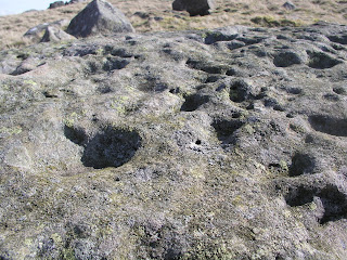
This time there were no such problems, the bracken was still dormant and the heather was low. I crossed the marshy ground and followed the drainage leat eastwards across the moor until I found the large flat slab with over 44 cup marks that had been my one and only find on my previous visit. This slab, listed as BAR 19c, looks like a storm is peppering the surface of a pond, cup after cup is dotted around the surface. Luckily this slab proved a fixed point for my micro navigations and armed with an eight-figure grid reference for BAR 19a I found it within seconds, some 20 meters off in a north north east direction.
BAR 19a is a small pyramidal shaped glacial erratic with its sloping upper surface decorated with four cup and ring motifs with attached grooves, surrounded by penannular rings. There are also several isolated cups on the panel which is situated close to a prehistoric enclosure wall. This was an exciting find with an intricate design but I was still looking for BAR 19b, a very complex panel comprised of cups, grooves and rings that was discovered under vegetation by Richard Stroud in 2006. This was the panel that had first interested me in Barningham Moor and I had seen several pictures of it on the web, glistening with the water that had been poured over it to bring the incisions into brighter relief. It is a truly spectacular and wonderful piece of art, the meaning of which we will never know and the location of which I seemed destined never to find.


I had an eight figure grid ref for BAR 19b and knew it must be close of the other stones in this group but try as I might I could not locate the panel. I quartered the area, walking outwards in ever increasing squares and returning to my fixed point until it clicked with me that the panel may have covered over again to prevent damage from the weather and the curious. I returned to the location suggested by the grid ref and there, amongst the turfs was a very small section of grey-blue stone poking out, no bigger than my thumb. Falling to my knees I peeled back the grass and moss like a carpet revealing BAR 19b in all its glory. Now open to the air, the waterlogged moss and turf which had been laid over the panel left behind a dark stain on the rock but as I watched the water began to evaporate in the cold wind and the rock shone with a pale grey sheen.
I dusted off the soil and lay flat to see the panel close up, prostrating myself as if before a shrine. On the skyline Odmonds Gill notched the line of the ridge. It was obvious that the pictures I had seen on the web had been lit and prepared, the covering turf carefully cut away and trimmed, the panel made wet to bring out the designs. Here was the panel revealed anew, earthy and raw. The literature describes how the peck marks from the tools can still be seen on the panel and up close the rock felt cold and rough. For me this was a moment to rival Howard Carter at the steps of the tomb of Tutanhkamun. If I was not the finder I realised that I must at least be one of a small number of people to view and touch the panel since its rediscovery in 2006.
The panels on Barningham Moor are as important to me as any national monument or work of art housed in a gallery. They are direct links back to our ancient past and still mark the High Places beneath which we live. There is a deep responsibility which comes with viewing such works of art and I felt as if I had lingered too long in a place that had not easily or willingly given up its secrets. I rolled the tuft back down over the panel, being careful to position them so no part of the panel was exposed. The gaps between the turfs I filled with handfuls of sheep pellets, letting them run down into the cracks, sealing the rock from frost and fire.


